
Orange County ZIP Code Coverage
The 2022 OCGIS USPS ZIP Codes map is the best local visualization found for Orange County ZIP geography. It shows delivery areas and postal labels, not a definitive ZIP-to-post-office directory. The representative entries below retain the map's place associations and flag the municipal issue that can affect a record search. The Post Office column intentionally does not assign a station where the research did not verify one. Confirm the complete address with USPS before relying on a ZIP code.
| ZIP | Areas Covered | Post Office | Notes |
|---|---|---|---|
| 10910 | Greenwood Lake and the eastern county edge | Verify by USPS | Postal geography can cross municipal and county expectations. |
| 10914 | Blooming Grove and South Blooming Grove area | Verify by USPS | Postal and municipal naming are shared but not identical. |
| 10917 | Circleville area | Verify by USPS | The ZIP boundary is not the Town of Wallkill boundary. |
| 10924 | Goshen postal area | Verify by USPS | Not all Town of Goshen addresses necessarily share one ZIP. |
| 10940 | Middletown | Verify by USPS | City and surrounding-town searches need a municipality field. |
| 10950 | Monroe | Verify by USPS | City, village, and town labels should not be conflated. |
| 10958 | New Windsor | Verify by USPS | The Town, City Newburgh, and postal labels require separate checks. |
| 10990 | Washingtonville | Verify by USPS | Town and village geography can differ from postal geography. |
| 12518 | Cornwall area | Verify by USPS | Use the full address for the delivery-city result. |
| 12550 | Newburgh | Verify by USPS | City Newburgh postal area is not identical to Town Newburgh. |
| 12586 | Walden | Verify by USPS | Village and town postal geography can differ. |
| 12771 | Port Jervis | Verify by USPS | City boundary and ZIP boundary are different concepts. |
The map also displays county-edge and rural delivery areas. Treat each as a geographic lead until a full address confirms it. Note: A postal city label should not replace the municipality field on a parcel, permit, court, or local-clerk request.
Orange County ZIP Code Map Labels
Other 109-area labels on the OCGIS map are 10915 Campbell Hall, 10916 Campbell Hall and nearby western Orange, 10918 Chester, 10919 Bullville, 10921 Florida, 10922 Fort Montgomery, 10925 Greenwood Lake area, 10926 Harriman, 10928 Highland Falls, 10930 Highland Mills, 10932 Howells, 10941 Middletown area, 10953 Mountainville, 10956 New Hampton, 10963 Otisville, 10969 Pine Island, 10973 Slate Hill, 10975 Sloatsburg, 10979 Sugar Loaf, 10985 Unionville, 10987 Warwick area, 10988 Vails Gate, 10992 Washingtonville area, 10993 West Haverstraw area, 10994 Westtown, and 10998 Westtown or nearby area.
The same map includes 10995, 10996, 10997, and 10999 as Orange County map labels without enough information to call them a post-office assignment. It also includes 12520 Clintondale and county-edge area, 12542 Marlboro, 12543 Maybrook, 12549 Montgomery, 12553 New Windsor, 12566 Pine Bush, 12575 Salisbury Mills, 12577 as an Orange County map label, and 12589 Wallkill-area geography. Western and northern labels include 12721 Cuddebackville, 12729 Glen Spey, 12746 Huguenot, 12780 Sparrow Bush, and 12785 as an Orange County map label. All need full-address USPS verification.
Orange County ZIP Code Geography
A ZIP code is a USPS delivery geography, while Orange County records use several other identifiers. The situs or property address is the physical location used by the assessor, GIS, permits, and emergency addressing. A mailing address is where an owner or organization receives correspondence and may be outside the parcel municipality or the county. A legal description or parcel number is the section, block, lot, subdivision, or metes-and-bounds language used in deeds and tax maps. Keep all three separate from a postal ZIP.
This distinction is especially important around Newburgh. City Newburgh, Town Newburgh, and Town New Windsor are different research contexts even when a postal name looks familiar. A Middletown or Port Jervis postal address can also sit outside the city boundary. County quick links name 44 municipalities, so a local record request needs the event or parcel municipality, not only the postal city.
Search Orange County ZIP Codes
Use a ZIP code to organize an address trail, not to create a ZIP-wide roster. Begin with the whole street address and preserve the delivery result. Then use the map and parcel tools to establish the municipality and parcel identifier. Once a postal area narrows the place, address-level research can move to the relevant custodian. The Orange County street directory contains the fuller by-address sequence for parcels, deeds, and municipal records.
- Run the full address through the USPS ZIP Code Lookup and record the returned postal city and ZIP.
- Use OCGIS Find Address or Place to locate the point, then note the municipality and parcel context.
- Search the county property route by address, owner name, tax-map number, or municipality, keeping the situs and mailing address separate.
- For an individual registration confirmation, enter the required name, county, date of birth, and ZIP in the state voter tool. A ZIP alone cannot perform that confirmation.
- Send a focused request to the municipal or county custodian only after the place and record type are known.
New York voter-file access has separate rules. A full-file request under Election Law section 3-103(5) must state an elections purpose, and protected records are withheld. Do not treat a person-specific result as a list for the surrounding ZIP.
Orange County ZIP Code GIS Inputs
OCGIS can use ZIP information as part of a place search, but the result is a map starting point rather than a certified location or title record. The county's GIS help says Find Address or Place accepts an address, city, state, and ZIP. A complete address is not required, the user chooses a geocoding service, live results narrow as terms are entered, and an incomplete search can return potential matches. From there, identify the parcel and follow the county assessor route for property information.
| Address | Accepted by GIS Find Address or Place; a complete entry is not required. |
|---|---|
| City | Helps separate a postal label from the intended municipal context. |
| State | Used with the address and city in the geocoding input. |
| ZIP | Accepted as part of the GIS input, but not a standalone parcel or household search. |
| Result | Zooms to a small circle or potential match, then supports map inspection. |
The county's Parcel Information page identifies owner name, address, tax map number, and municipality as its search routes. Its property information should be checked against the local assessor's official roll when an update matters.
Orange County ZIP Code Voter Fields
The state voter service is confirmation-oriented. The NYS Voter Registration Search requires county, last name, first name, date of birth in MM/DD/YYYY format, and ZIP code. Cookies and JavaScript are required. A match can return registration, poll-site, and mail-ballot tracking information. A nonmatch does not establish that someone is not an Orange County resident, because spelling, address, status, timing, confidentiality, and eligibility affect the result.
A source-linked view of the state voter form is shown below.
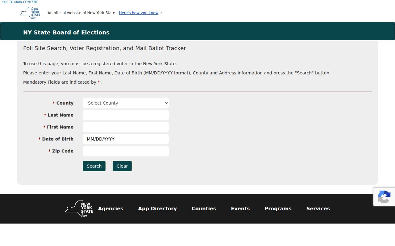
The required ZIP field supports an individual confirmation only when used with the other required fields; it is not a ZIP-level directory.
Orange County ZIP Code Boundaries
ZIP boundaries do not establish city, town, village, school-district, or election-district limits. OCGIS supplies a local map view, while USPS gives the final delivery answer for a complete address. For a record search, use the map to identify the nearby municipal line and parcel geography, then use the municipality field in the assessor or local-office route. The county's election-district maps provide a separate geography for elections.
The map labels also cross county edges. That is why an Orange County postal label can point beyond the city or town expected from a tax record. The full address remains the final check for delivery geography.
Orange County ZIP Code Glossary
Postal terms are useful when they describe the address field being checked. They are not substitutes for the municipal and parcel identifiers that Orange County offices use. The research did not establish fine carrier-route coverage or a full post-office assignment for every mapped ZIP, so those details should be verified from USPS rather than inferred from a map label.
- ZIP
- A USPS delivery-area code. It helps route mail but does not draw a municipal boundary.
- ZIP+4
- An added four digits that further sorts mail for a specific delivery segment or address. USPS supplies it from a complete address.
- PO-box ZIP
- A code used for post-office-box delivery. This research did not verify a PO-box-only Orange County ZIP list.
- Carrier route
- A delivery sequence used by USPS. Fine Orange County route coverage was not established in the research.
Orange County ZIP Code Research
For historical work, pair the postal ZIP with a street index and the parcel legal description. Postal names can survive while a municipal label changes, and an old address may have a renamed street or different number. Newburgh's 1935 street-name publication and its post-1918 address-searchable directories are useful local bridges. Preserve the old and current forms rather than forcing one into the other.
When an online search stops, the Orange County Record Room, local libraries, the Historical Society, and the County Clerk's historical resources may supply the next source. Use the ZIP as a way to orient the address, then cite the actual repository and record year. Note: A ZIP code supports location context, but the parcel and municipal record establish the official research route.